1. Introduction
1.1. Purpose and Scope
The Lunar Orbiter Laser Altimeter (LOLA) is producing a high-resolution global topographic model and geodetic framework that enables precise targeting, safe landing, and surface mobility to carry out exploratory activities. LOLA characterizes the polar illumination environment, and images permanently shadowed polar regions of the Moon to identify possible locations of surface ice crystals in shadowed polar craters.
This Software Interface Specification document provides users of the Lunar Reconnaissance Orbiter (LRO) LOLA Reduced Data Record (RDR), the Gridded Data Record (GDR) and Spherical Harmonic Data Record (SHADR) data products, with a detailed description of the product and how it was generated, including data sources and destinations.
1.2. Contents
This Data Product SIS describes how the RDR data product is processed, formatted, labeled, and uniquely identified. The document discusses standards used in generating the product and software that may be used to access the product. The data product structure and organization is described in sufficient detail to enable a user to read the product. Finally, an example of a product label is provided.
1.3. Applicable Documents and Constraints
This SIS is intended to be consistent with the following documents:
1. Planetary Science Data Dictionary Document, JPL D-7116, Rev. E, August 28, 2002.
2. Lunar Reconnaissance Orbiter Project Data Management and Archive Plan, 431-PLAN-00182.
3. ISO 9660-1988, Information Processing - Volume and File Structure of CD-ROM for Information Exchange, April 15, 1988.
4. Planetary Data System Archive Preparation Guide, August 29, 2006, Version 1.1, JPL D-31224.
5. Planetary Data System Standards Reference, March 20, 2006, Version 3.7, JPL D-7669, Part 2.
6. LRO LOLA Science Team and PDS Geosciences Node ICD, October 9, 2006.
7. Lunar Reconnaissance Orbiter Project LOLA Instrument Team Data Management and Archive Plan, April 1, 2007.
8. LOLA Archive Volume Software Interface Specification, V2, October 26, 2008.
9. Memorandum of Agreement between the PDS Geosciences Node and the LRO LOLA Data Node, Washington University, St. Louis, Missouri, and the LRO LOLA Instrument Team, Goddard Space Flight Center, Greenbelt, Maryland, October 27, 2006.
10. A Standardized Lunar Coordinate System for the Lunar Reconnaissance Orbiter, LRO Project White Paper, 451-SCI-000958, Version 3, January 30, 2008.
11. Lunar Reconnaissance Orbiter Lunar Orbiter Laser Altimeter Experiment Data Record Software Interface Specification (LOLA EDRSIS), V.2, October 26, 2008.
12. LOLA Calibration Document, Riris, H., J. Cavanaugh, X. Sun, and P. Liiva, Submitted to Applied Optics, 2010.
1.4. Configuration Management and Relationships with Other Interfaces
The RDR and higher-level products described in this SIS are used in the production of other archived products of the LRO mission. Changes to this specification will require concurrence of the Principal Investigator, the LRO Project Science Data Manager, and the Planetary Data System Geosciences Discipline Node.
2. Data Product Characteristics and Environment
2.1. Instrument Overview
The LOLA instrument, designed, assembled and tested by the NASA Goddard Space Flight Center (GSFC), has two primary objectives. First, to produce a high-resolution global topographic model and geodetic framework that assists with precise targeting, safe landing, and surface mobility for future scientific and exploration activities. Second, to characterize the polar illumination environment and image the Moon’s permanently-shadowed regions (PSRs) in order to identify possible locations of surface ice crystals in shadowed polar craters. To achieve these primary objectives, LOLA will make three science measurements:
1) the distance between the surface and the spacecraft,
2) the spreading of the returned laser pulse, and
3) the transmitted and returned laser energies.
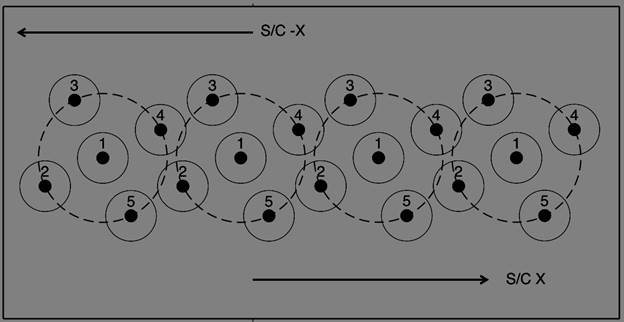
LOLA is a pulse-detection time-of-flight altimeter that incorporates a five-spot pattern to measure the precise distance to the lunar surface at 5 spots simultaneously, thus providing 5 profiles across the lunar surface. Figure 1 shows the spot pattern used, where the dots are the transmitted laser footprints, and solid circles are receiver fields-of-view. LOLA fires at a fixed, 28-Hz rate, so that for a nominal 1600 m/s ground track speed there is one shot approximately every 57 m. At a nominal 50-km altitude, each spot within the five-spot pattern has a surface diameter of 5 m while each detector field of view has a diameter of 20 m; the surface spread is 25 meters, and the spots form a cross pattern canted by 26 degrees counterclockwise to provide five adjacent profiles.
The 5-spot pattern determines the surface slope in the along-track and across track directions. LOLA’s design is similar to the Mars Orbiter Laser Altimeter (MOLA) and the Mercury Laser Altimeter (MLA), augmented by a novel diffractive optic element (DOE). LOLA has five independent detectors coupled via fiber optics to the receiver telescope and five receiver channels (1-5). Channel 1 is also fiber-optic-coupled through a dichroic beamsplitter to a Laser Ranging (LR) telescope mounted on the High-Gain Antenna. An R-C filter with a decay time constant of 3.4 ns is applied to the detector output for noise suppression.
The 5-spot pattern determines the surface slope in
the along-track and across track directions. LOLA’s design is similar to the
Mars Orbiter Laser Altimeter (MOLA) and the Mercury Laser Altimeter (MLA),
augmented by a novel diffractive optic element (DOE). LOLA has five independent
detectors coupled via fiber optics to the receiver telescope and five receiver
channels (1-5). Channel 1 is also fiber-optic-coupled through a dichroic
beamsplitter to a Laser Ranging (LR) telescope mounted on the High-Gain
Antenna. An R-C filter with a decay time constant of 3.4 ns is applied to the
detector output for noise suppression.
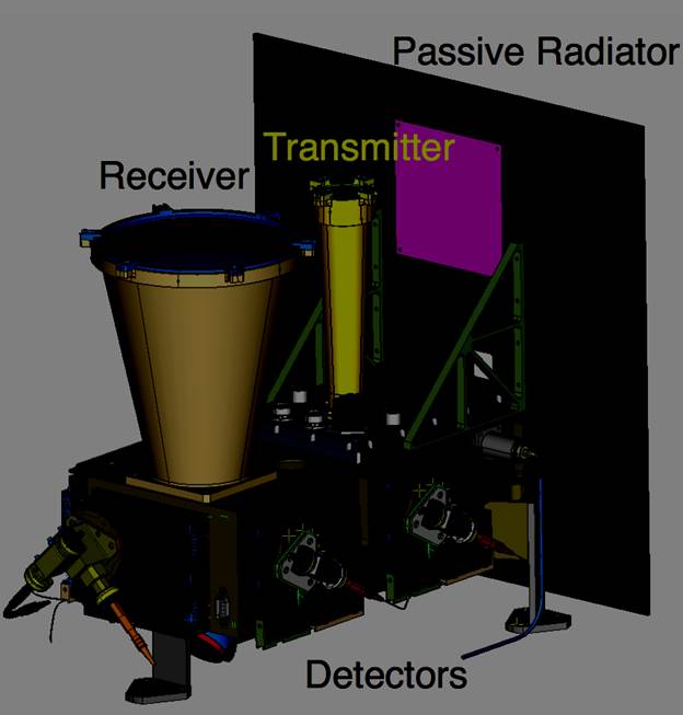
Figure 2: LOLA Optical Transceiver Assembly.
LOLA's altimetry observations are global. Timing of one-way pulses fired from Earth to the LR are employed to improve navigation and lunar gravity determination. The LOLA instrument is a pulsed laser time-of-flight altimeter, operating continuously during mapping orbit to produce altimetric ranges that are stored on the LRO spacecraft (SC) for playback. Its housekeeping (HK) data are also provided in a realtime data stream and contain information regarding the flight software status and the Laser Ranging signals from Earth stations.
The instrument hardware consists of laser transmitters, receivers, and passive radiator subsystems mounted in an Optical Transceiver Assembly (Figure 1), together with a Power Converter Assembly and Digital Unit mounted in the Main Electronics Box. There are two redundant lasers coupled to the transmit optics, selectable by software command. Transmit and receive pulses are measured with independent leading and trailing edge times using ACAM TDC-S1 chips designed for space docking applications (offset by a 5 MHz coarse count.) Energy is monitored via a gated charge-time measurement circuit with digitizer. The instrument is co-boresighted with the LRO Cameras on the spacecraft +Z optical bench. The main technical details regarding the instrument are given in Table 1.
Table 1: LOLA Instrument Technical Details.
|
Item |
Measure |
Comment |
|
Mass |
13.2 kg |
(at Critical Design Review 7/06) |
|
Power |
33.5 W |
(average) |
|
Data rate |
27 kbps |
3424 Bytes, 1 packet per second |
|
Lasers |
2 (1 cold spare) |
Cr:Nd:YAG cross-Porro resonator, TEM00, TEC cooled |
|
Wavelength |
1064.3±0.1 nm |
|
|
Diode bars |
2 |
60 A, 140-160 μs pump, with passive Cr4+:YAG Q-switch |
|
Pulses |
28 Hz, 2.7±0.3 mJ |
5.6 ns FWHM |
|
Thermal |
passive radiator |
Laser operating range: 5°C to 35°C |
|
Detectors |
5 Si-APDs |
preamp bandwidth 100 Mhz, followed by R-C 3.4 ns filter |
|
Quantum Efficiency |
0.4 |
@1064 nm |
|
Detector noise |
0.05 pW/Hz1/2 |
Noise equivalent power |
|
Optics |
Receiver |
Transmitter after 18x Beam Expander and DOE |
|
Objective |
Sapphire |
BK7G18/fused silica DOE |
|
Obj. diameter |
14 cm |
3.24 cm |
|
Obj. area |
0.015 m2 |
8.245 cm2 |
|
Transmission |
>70% |
>95% |
|
Effective F. L. |
50.0 cm |
16.2 cm |
|
F.O.V. 1/e2 |
400 μrad |
100 μrad, separation between adjacent beams is 500 μrad |
|
Fiber Optic |
200 μm, 0.22NA |
LR is a 7x400um core, 0.22NA, step-index, 1.28mm bundle |
|
Bandpass filter |
dichroic beamsplitter |
Δλ=0.7nm, λ=1064.45 nm; LR λ =532.15 nm, Δλ= 0.3 nm |
Instrument modes (Table 2) are controlled by ground command. Independent of these modes, the Flight Software (FSW) may be active or commanded to a reset state. The digital unit outputs data directly to the SC over the 1553 bus in either case. Thresholds, gains, and range gates are normally controlled by the FSW algorithm. The algorithm seeks to maximize the probability of detection within a range window under varying background noise conditions, by utilizing hardware noise counters in a fashion similar to that employed on the MOLA and MLA instruments. There are two separate range windows within the LOLA timing electronics, one for the Earth-based LR pulses, and a second variable lunar range window that only allows triggers during the interval of time when the FSW return histograms predict surface returns. Since only one lunar return is recorded, a separate counter records the number of events within each range window. To accommodate the large dynamic range of lunar return strength, a variable gain amplifier is implemented in hardware prior to the discriminator input. The gain is set according to tables of gain vs. lunar range, one for each detector. Earth laser ranges are recorded by detector 1 during the 8 ms preceding each laser fire, using the same threshold and gain settings as for lunar ranges. Owing to higher background Earth counts, especially during New Moon phases, the detector 1 thresholds are higher than those of the detector 2-5 channels.
|
Mode |
Telemetry |
Laser |
Detector |
|
Measurement |
HK, Science |
Firing enabled, 28Hz trigger |
Active-LR and lunar return |
|
Standby 2 |
HK, Science |
Firing enabled, capacitors charged |
Active-LR and noise |
|
Standby 1 |
HK, Science |
Laser TEC active |
Active-LR and noise |
|
Off |
Analog temps |
Survival heaters enabled |
Inactive |
2.2. Data Product Overview
The LOLA RDR data product consists of time-of-flight ranges to the lunar surface and ancillary data that have been located in a geodetic coordinate frame about the center of mass of the Moon. This planetocentric coordinate frame is described further as the Mean-Earth/polar Axis convention in section 2.4.3 and Applicable Document 10. The EDR data product is the source of the measurement data. After range calibration and orbital processing, the range to each laser spot is located on the surface using the spacecraft trajectory, attitude history, and a lunar orientation model in order to produce an altimetric datum. The range profiles are organized into an RDR product containing calibrated, geolocated pulse returns, radii and energies; and higher-level gridded and transformed data products.
The RDR data product is a binary table with fixed-length
records. The binary table is in a PDS standard format that can be stored,
managed and reprocessed efficiently without loss of precision. It can be
converted to the equivalent engineering and scientific units for import into
analysis software by standard formatted output specifications (see Section 4).
This choice also maximizes flexibility for users who may wish to handle only
selected data values, or who may wish to import them into
geographically-organized databases. Record columns consist of uniform-length,
4-byte integer values, stored in Least-Significant Byte (LSB_INTEGER) order
that may be converted to Most-Significant Byte (MSB_INTEGER) order by a single
global transformation. Both UNSIGNED and SIGNED INTEGER types
are employed.
The RDR product is used to generate derived data products
(RADR, GDR, SHADR) that are binned, resampled, and transformed. The RADR
product is time-ordered, calibrated and geolocated active radiometry derived
from the RDR product using data gathered during the Nominal Mission phases.
RADR files are archived as asciiASCII
tables with detached labels, organized by LOLA mission phase.
The primary GDR products are map-projected digital elevation models and related products. Additional GDR products include gridded albedo, slope and roughness maps. Albedo (RADR) products are derived from nominal mission data only, and are further limited – not every return with valid altimetry has a corresponding albedo value, as the energy measurement quality depends on both the laser return and the solar incidence angle. Low data density results in some 'streakiness' seen in the gridded albedo products.
Digital elevation models are
transformed into spherical harmonic expansions to produce the SHADR products.
Much of the processing of the RDR product may be used to reconstruct and
improve the geometric information regarding the spacecraft position, attitude,
and clock history. The improved geometry will be archived in the SPICE format
through the PDS Navigation and Ancillary Information Facility (NAIF) Node.
Much of this improvement is anticipated to result from the Laser Ranging Experiments on board LRO, for which data are returned through the LOLA instrument. This investigation is separate from that of the altimeter but is intimately coupled. The Laser Ranging data are originated by ground stations under the auspices of the LRO Project and are collated with Earth returns in the LOLA data stream by the LOLA SOC. They are provided to the Flight Dynamics Facility and to the participating stations of the International Laser Ranging Service by the Crustal Dynamics Data Information Service at GSFC. Derived LR products will not be included in this archive.
The
LRO SC stores LOLA science data in a file on the SC data recorder in a
subdirectory called “SSR/LOLA/”. Prior to powering on the instrument, the SC
opens the data file and writes the LRO standard file header data. As new data
frames are read over the 1553 bus, the SC writes them to the file without
modification. The SC closes the file, open a new file, and writes another LRO
standard file header when commanded to do so by the ground controllers (this
will nominally be scheduled to occur once per lunar orbit at ascending equator
crossings, roughly 6,785 seconds apart). Files are always closed on a packet
boundary so that packets are not divided between files. During the daily
downlink tracking passes these files are transmitted from the SC to the LRO
Ground Data System and are pushed by the LRO Mission Operations Center (MOC) to
the LOLA Science Operations Center (SOC) computer. Each file is
then processed in a pipeline at the SOC.
The orbital period of the LRO spacecraft varies somewhat with mission phase, and is approximately 112-114 minutes in duration. The orbit duration will determine the precise number of RDR files, but they will not exceed 13 per day. The geolocation processing cycle will aggregate the data records into daily batches in order to facilitate analysis. The LRO Project uses an orbital numbering convention whereby the orbit number increments from 0 to 1 on the first ascending node after completion of the LOI-1 lunar insertion maneuver, and increments by 1 on every ascending node after that. Table 3 summarizes expected sizes and production rates for the Reduced Data and Derived products.
Table 3: Standard Product Sizes and Delivery Rates
|
Product |
Product Size |
Production Rate per Day, average |
Expected Number of Products for Primary Mission (366 days) |
Expected Total Data Volume for Primary Mission |
|
LOLA_RDR |
~50 MB |
same |
4670 |
225 GB |
|
LOLA_RADR |
<10 MB |
Same as LOLA_RDR |
4162 |
27 GB |
|
LOLA_GDR |
<2 GB |
monthly revisions of ~100 data products |
100 |
200 GB |
|
LOLA SHADR |
<5 MB |
release at ~quarterly intervals |
4 |
<1 GB |
2.3. Data Processing
The pipeline data processing begins by generating an EDR product with a detached PDS label, in one-to-one correspondence with the files generated by the instrument on the LRO spacecraft, corrected for transmission errors, gaps and duplicates where possible. The format of the files is identical to that on the spacecraft. LOLA operates continuously, generating one 3,424-byte record each second, with an associated 12-byte telemetry header. The telemetry header information is captured in a detached "PDS3" version ASCII label. During tracking passes, the instrument housekeeping portion of the telemetry is transmitted via a real-time connection for use by the LR ground system, but is not archived since it is duplicated in the EDR product. The aggregate data rate is approximately 300 MB per day.
The EDR products are geolocated using preliminary and definitive orbits produced by the LRO Flight Dynamics Facility in order to determine approximate nodal crossing times. The Data Records are then aggregated by orbit number and geolocated into the RDR products using precision orbit reconstructions and calibration algorithms. Each 1-Hz record of the EDR corresponds to 28 laser shots and produces 28 records in the RDR. Instrument engineering values such as algorithm status, detector status (noise counts, temperatures, etc.) from the EDR are not included in the RDR records.
2.3.1. Data Processing Levels
Table 4 gives descriptions of Committee on Data Management and Computation (CODMAC) product levels.
Table 4: Processing Levels for Science Data Sets.
|
NASA |
CODMAC |
Description |
|
Packet data |
Raw – Level 1 |
Telemetry data stream as received at the ground station, with science and engineering data embedded. |
|
Level 0 |
Edited – Level 2 |
Instrument science data (e.g., raw voltages, counts) at full resolution, time ordered, with duplicates and transmission errors removed. |
|
Level 1A |
Calibrated - Level 3 |
Level 0 data that have been located in space and may have been transformed (e.g., calibrated, rearranged) in a reversible manner and packaged with needed ancillary and auxiliary data (e.g., radiances with the calibration equations applied). |
|
Level 1B |
Resampled - Level 4 |
Irreversibly transformed (e.g., resampled, remapped, calibrated) values of the instrument measurements (e.g., radiances, magnetic field strength). |
|
Level 1C |
Derived- Level 5 |
Level 1A or 1B data that have been resampled and mapped onto uniform space-time grids. The data are calibrated (i.e., radiometrically corrected) and may have additional corrections applied (e.g., terrain correction). |
|
Level 2 |
Derived - Level 5 |
Geophysical parameters, generally derived from Level 1 data, and located in space and time commensurate with instrument location, pointing, and sampling. |
|
Level 3 |
Derived - Level 5 |
Geophysical parameters mapped onto uniform space-time grids. |
This document is intended to provide enough information to enable planetary scientists to read and understand the format and content of the higher-level LOLA Archive. The specifications in this document apply to all LOLA standard product archive volumes that are generated by the LRO Project. The RDR data product contains the time-ordered LOLA measurement data in reduced, calibrated and geolocated form, one record per laser shot. The altimetric and related measurements generate the GDR and SHADR data products. The GDR data products contain the binned, interpolated altimetric measurements, as well as albedo, roughness, and surface slope both in cylindrical and polar projections. The SHADR products contain the spherical harmonic expansions of the lunar shape.
For geological characterisation, topography is referenced to a non-spherical datum, such as an ellipsoid of revolution, or in the case of Earth, a geoid. The lunar potential derived from satellites provides the equivalent datum for the Moon, referred to as the planetopotential reference surface.
The EDR product is CODMAC level 2 (Table 4), consisting of raw counts, edited to correct transmission errors and eliminate duplicates. In order to be useful for measurement and geological investigations, the data must be classified to determine whether individual laser shots are valid pulses and produce ground returns above the background noise level of detection. These data must be calibrated to engineering and physical units, and located in a center-of-mass coordinate system. The RDR and RADR data products are CODMAC level 3. Binned and interpolated data on a uniformly-spaced grid (GDR) comprise the CODMAC level 4 data products, while transformed spherical harmonic coefficients (SHADR) comprise CODMAC level 5.
2.3.2. Data Product Generation
All data products at CODMAC level 2 and higher are generated by the LOLA SOC. Raw data are not subject to decompression, as the full instrument output counts are stored in the telemetry packets. Following EDR generation, software algorithms perform calibration, geolocation, and editing to eliminate noise. Calibration consists of conversion of raw counts into laser time-of-flight ranges, pulse widths, and energies, using tables and algorithms based on ground test data. Editing consists of generating data quality flags for each laser pulse return, to distinguish between probable lunar returns and noise triggers, and to flag anomalous measurements. Algorithms and ancillary data used in the RDR processing are described in the LOLA Instrument Calibration Document, Applicable Document #12 (sec. 1.3).
During the primary mission, the LRO spacecraft performs propulsive orbital adjustment maneuvers at monthly intervals. These maneuvers terminated the dynamical orbital solutions and provided a natural breakpoint for altimetric reprocessing. Multiple versions of the RDR and some higher-level products are generated based on a monthly reprocessing and validation step, as orbit knowledge improves and refined crossover adjustments are performed. Each new version of the data products replaces all of the older products and supersedes all previous versions in the electronic archive, and is identified as such in the PRODUCT_VERSION_ID fields of the PDS labels. This approach of periodic reprocessing is in accordance with the cumulative improvement in coverage density and orbital knowledge inherent to laser altimetric missions.
2.3.3. Data Flow
Data are pushed directly from the LRO MOC through the GSFC Internet backbone to the LOLA SOC, where processing occurs. The LOLA SOC serves as a Data Node of the PDS. Data products and catalogs are made available to the PDS via a Query Server connection as well as by other electronic means. Sizes and volumes of all the data products generated over the course of the primary mission are given in Table 3. The data products cover variable time spans according to their processing level. A monthly reprocessing cycle is applied to all CODMAC Level 3 and higher products, following which new versions of current and previous products are redelivered to the Data Node. At 3-month intervals as specified in the Data Management and Archive Plan (Applicable Document 2), validated releases of a cumulative archive will be made. It is anticipated that only the current version of data products will be maintained after the specified releases.
2.3.4. Labeling and Identification
The data set IDs provided by the PDS for the LOLA RDR and higher level data products are:
"LRO-L-LOLA-3-RDR-V1.0", “LRO-L-LOLA-3-RADR-V1.0”, "LRO-L-LOLA-4-GDR-V1.0", and "LRO-L-LOLA-5-SHADR-V1.0".
The file naming convention for LOLA RDR files is:
LOLARDR_YYDDDHHMM.DAT
, in parallel with the EDR product.
The LOLA RADR files are similarly named, with a TAB extension corresponding to
an asciiASCII
table. PDS detached labels with a suffix of “.LBL” provide information about
processing and calibration version. Details about label and header formats are
specified in section 6. Labels
are subject to revision after monthly reprocessing, but the product filenames
will not be modified.
2.4. Standards Used in Generating Data Products
2.4.1. PDS Standards
LOLA data products comply with PDS standards for file formats and labels, as described in the PDS Standards Reference, Applicable Document 5 (sec. 1.3).
2.4.2. Time Standards
All time tags are derived from the LRO internal clock, whose performance is monitored by the Project. The PDS labels for LOLA products use keywords denoting time values, such as start time, stop time, start spacecraft clock count, and stop spacecraft clock count. Each time value standard is defined according to the PDS keyword definitions. Project-supplied conversions from Mission Elapsed Time (MET) to Coordinated Universal Time (UTC) include a Spacecraft Time Correction Factor that is included in the nominal time values. Geolocation software is based rigorously on Barycentric Dynamical Time, a convention that is realized through Terrestrial Dynamical Time (TDT) and orbital theories. The supplied MET-UTC conversions are specified to be accurate within 3 ms, during which time the SC ground track travels approximately 5 meters, or one laser spot diameter. Laser Ranging and orbital analysis are used to reconstruct the observation time to a significantly higher level of accuracy, which is recorded in the RDR data product both in MET seconds and TDT seconds from the J2000 epoch.
2.4.3. Coordinate Systems
Spatial information is applied in conversion of laser altimetric bounce points from inertial coordinates to lunar body-fixed coordinates about the center of mass of the Moon, or planetocentric coordinates. The LRO project adopts the Mean-Earth/polar axis convention, LRO data use lunar planetocentric/body-fixed coordinates and east-positive longitude from 0 to 360 degrees.
The ME reference system is used for all LRO archival data. This LRO standard is documented in Applicable Document 10 (sec. 1.3). Using coordinates in the ME system is consistent with recommendations from the International Astronomical Union (IAU)/International Association of Geodesy (IAG) Working Group on Cartographic Coordinates and Rotational Elements, as implemented by the LRO Data Working Group (LDWG).
The NAIF node of the PDS provides the necessary lunar ephemeris file (SPK) and binary lunar orientation file (PCK) in a Principal Axes (PA) reference frame for use with the SPICE Toolkit. NAIF also provides the frames kernel (FK) used for accessing the PA orientation in the PCK and for transforming from the PA frame to the ME frame.
2.4.4. Data Storage Conventions
The least-significant-byte (LSB) byte order is adopted for archival purposes, consistent with native i386 (PC) storage. Architecture-specific dependencies in the RDR product are mitigated through adoption of a consistent integer byte order and uniform 4-byte word size, with the exception of the last six columns containing solar and Earth information, which are half-words. During intermediate processing, MSB or LSB byte order native to the processing computer may be employed.
2.5. Data Validation
Data validation shall be applied to data products by the LOLA Measurement Team to ensure that their contents and format are free of errors and comply with PDS archive standards (Applicable Document 5). For the RDR product this consists of a combined orbit-determination and crossover residual analysis. The RDR and higher-level products will be re-released at approximately monthly intervals after such analysis is completed.
3. Detailed Data Product Specifications
The LOLA RDR data products are stored as fixed-length,
fixed-format binary tables. The LOLA RADR data products are formatted asciiASCII
tables. The detached PDS labels for LOLA RDRs and RADRs are stored as ASCII
text in fixed-length records terminated by an ASCII carriage-return and
line-feed pair. The product
labels point to the corresponding data
files, and contain pointers to format files. The GDR data products are stored
as binary images and as JPEG-2000 files with GeoTIFFtiff
headers, where appropriate. The SHADR data products are Comma-Separated Value
(CSV) ASCII text files with attached labels.
3.1. Data Product Structure and Organization
The
DATA/LOLA_RDR and DATA/LOLA_RADR directories have subdirectories for each
monthly orbital maneuver cycle named LRO_PP_NN, where PP refers to the first
two letters of mission phase (CO = Commissioning, NO = Nominal, SM
= Science Mission, ESX
= Extended Science Mission), and NN is refers to
the current monthly orbital cycle, ending with
Station Keeping Maneuvers, starting with 01. Typical file paths are
therefore
/DATA/LOLA_RDR/LRO_PP_NN/LOLARDR_YYDDDHHMM.DAT and
/DATA/LOLA_RAaDR/LRO_PP_NN/LOLARDR_YYDDDHHMM.DAT,
where YYDDDHHMM is the time of the ascending node crossing. The orbit numbering convention may also be used for special products. Orbit number is determined by the MOC, incrementing at each ascending equator crossing.
The LOLA_GDR directory has subdirectories for JPEG2000 and IMG files. The LOLA_SHADR directory has no subdirectories.
3.2. Data Format Descriptions
The LOLA RDR table format description is given in Appendix 1.
The RDR format file is “LOLARDR.FMT”. This column definition file is stored in
the /LABEL directory of the LOLA archive.
The GDR and SHADR formats are contained in their respective labels.
3.3. Label and Header Descriptions
An example of a detached PDS RDR label follows. The SOURCE_PRODUCT_ID contains information regarding the raw datasets and geometry processed for a given version. The PRODUCT_VERSION_TYPE contains the instrument range calibration, energy calibration, pulse spreading calibration, background illumination calibration (radiometry from noise counts), gravity model, and reprocessing level. The INSTRUMENT_MODE_ID is relevant to the slight offset in alignment of the two redundant lasers, for geolocation, and the timing source for firing. The LRO:STCF_FILE_NAME contains an offset from spacecraft clock counts to Coordinated Universal Time relative to January 1, 2001, 0 hours. The remainder of the parameters are generic and need not be described in detail. Sample PDS RADR, GDR and SHADR labels are given in Appendices.
PDS_VERSION_ID = "PDS3"
/*** FILE FORMAT ***/
FILE_NAME = "LOLARDR_092000107.DAT"
FILE_RECORDS = 200480
RECORD_TYPE = FIXED_LENGTH
RECORD_BYTES = 256
/*** GENERAL DATA DESCRIPTION PARAMETERS ***/
PRODUCT_ID = "LOLARDR_092000107_DAT"
PRODUCT_VERSION_ID = "V1.01"
PRODUCT_CREATION_TIME = 2009-08-29T20:28:10
PRODUCT_TYPE = "RDR"
STANDARD_DATA_PRODUCT_ID = "DATA"
SOFTWARE_NAME = "LOLA_RDR"
SOFTWARE_VERSION_ID = "2.45"
SOURCE_PRODUCT_ID = {"LOLAEDR092000107.DAT", "jgl150q1.sha"}
SPICE_FILE_NAME = {
"moon_pa_de421_1900-2050.bpc",
"moon_080317.tf",
"moon_assoc_me.tf",
"naif0009.tls",
"de421.bsp",
"lro_frames.tf",
"lro_sclk.tsc",
"fdf29_2009199_2009200_n01.bsp",
"fdf29_2009200_2009201_n01.bsp",
"fdf29_2009201_2009202_n01.bsp",
"moc42_2009199_2009200_v01.bc",
"moc42_2009200_2009201_v01.bc",
"moc42_2009201_2009202_v01.bc"}
COORDINATE_SYSTEM_NAME = "MEAN EARTH/POLAR AXIS OF DE421"
INSTRUMENT_HOST_NAME = "LUNAR RECONNAISSANCE ORBITER"
INSTRUMENT_NAME = "LUNAR ORBITER LASER ALTIMETER"
INSTRUMENT_ID = "LOLA"
DATA_SET_ID = "LRO-L-LOLA-3-RDR-V1.0"
DATA_SET_NAME = "LRO MOON LASER ALTIMETER 3 RDR V1.0"
MISSION_PHASE_NAME = "COMMISSIONING"
TARGET_NAME = "MOON"
PRODUCER_ID = LRO_LOLA_TEAM
PRODUCER_FULL_NAME = "DAVID E. SMITH"
PRODUCER_INSTITUTION_NAME = "GODDARD SPACE FLIGHT CENTER"
PRODUCT_RELEASE_DATE = 2009-10-06
ORBIT_NUMBER = 295
START_TIME = 2009-07-19T01:07:12.928
STOP_TIME = 2009-07-19T03:06:31.929
SPACECRAFT_CLOCK_START_COUNT = "2628408"
SPACECRAFT_CLOCK_STOP_COUNT = "2635567"
INSTRUMENT_MODE_ID = {"SC_B",
"LASER_2 ",
"ENABLED",
"FIRING",
"GAINS_DIS",
"THRESHOLDS_FSW",
"RGATES_FSW",
"SWINPUTS_FSW"}
FILE_NAME = "LOLARDR_092000107.DAT"
^TABLE = "LOLARDR_092000107.DAT"
OBJECT = TABLE
COLUMNS = 60
INTERCHANGE_FORMAT = BINARY
ROW_BYTES = 256
ROWS = 200480
DESCRIPTION = "
This product contains time-ordered, calibrated, geolocated data
reduced by the LRO Lunar Orbiter Laser Altimeter (LOLA) Science
Operations Center at NASA Goddard Space Flight Center. Orbit and
geometry data describing the observations has been supplied by the
LRO Flight Dynamics Facility and the LOLA Science Team.
The complete column definitions are contained in a structure file
LOLARDR.FMT. Additional details are contained in the RDR SIS document."
^STRUCTURE = "LOLARDR.FMT"
END_OBJECT = TABLE
END
4. Applicable Software
Signed and unsigned four-byte integers represent the RDR data values with sufficient precision to avoid roundoff errors. Because the LOLA RDR data products are formatted as binary tables, they must be read by software that understands PDS table formats and can manipulate byte-order-dependent fields. The primary access to the data product is through the table definitions herein described. Software to read and format the data into ASCII text will be maintained by the LOLA Team for commonly used platforms. The PDS Geosciences Node will maintain the most current versions of software for download by users through the Internet, along with the data. The general public may also access the data through geographically-based queries to databases.
4.1. Utility Programs
A stand-alone utility 'rdr2csv' converts an RDR into a 28-Hz, CSV text file. It is linked with the NAIF SPICE library and requires a table of leap seconds (naif0009.tls). The CSV file may contain up to 200,000 records and may not be supported as a single table by legacy spreadsheet software. Another utility 'rdr2table' will output each valid detector measurement to an ASCII table, with various selection options. Calibrations for energy, surface reflectivity, pulsewidth, and so forth are applied in these programs. They are written in FORTRAN-77 and C and may be easily modified.
For example, to create a spreadsheet table with header:
rdr2csv LOLARDR_100322338.DAT > LOLARDR_100322338.csv
To output height from all 5 detector spots as a table with header:
rdr2table LOLARDR_100322338.DAT a h | head -7
SCLK_LOLA alt_km id longitudeE latitudeN range_km energy noise thrs gain flg reflect pulsewd
0.000 -1.3782 1 21.887972 0.188501 42.772 0.3771 3 31.3713 50.2106 0 0.18274 22.15
0.000 -1.3801 2 21.888284 0.187860 42.773 0.2321 7 28.7125 49.8681 0 0.13246 19.14
0.000 -1.3799 3 21.887322 0.188194 42.774 0.2630 7 28.6896 49.9720 0 0.15510 16.72
0.000 -1.3759 4 21.887647 0.189134 42.770 0.2852 5 25.5802 49.2268 0 0.11895 16.88
0.000 -1.3763 5 21.888602 0.188800 42.769 0.3402 4 30.1136 50.1560 0 0.15275 19.65
0.036 -1.3712 1 21.887913 0.190412 42.765 0.4207 3 31.3713 50.2106 0 0.21893 21.84
0.036 -1.3731 2 21.888225 0.189772 42.766 0.2124 9 28.7125 49.8681 0 0.11168 18.66
To output geopotential topography on detectors 3 and 4:
rdr2table LOLARDR_100322338.DAT g 3 4 |head -2
0.000 -1.3981 3 21.887322 0.188194 42.774 0.2630 7 28.6896 49.9720 0 0.15510 16.72
0.000 -1.3941 4 21.887647 0.189134 42.770 0.2852 5 25.5802 49.2268 0 0.11895 16.88
To output spacecraft position/attitude, flagged returns, and transmit energy/pulsewidth:
rdr2table LOLARDR_100322338.DAT 0 h f | head -2
SCLK_LOLA sc_alt 0 sc_longE sclat_N offnadir emission ifrm solinc solphs ngrd xenrg xplse
0.000 41.3700 0 21.934303 0.187423 1.882 1.9280 0 55.3735 57.3015 5 2.67470 8.79
0.036 41.3701 0 21.934281 0.189339 1.885 1.9309 1 55.3735 57.3044 5 2.63386 8.90
Faster binary output is generated by rdr2xyz <RDRFILE> <OUTFILEROOT.xyz> <options>.
4.2. Applicable PDS Software Tools
The PDS-D query software is available to extract metadata from catalogs and download specific data products from a web browser. Software tools are also being developed by the PDS Geosciences Node such as Orbital Data Explorer. NASAVIEW, a generic software reader for PDS-formatted files, can be also be used to inspect the binary RDR data files but is not fully supported on all operating systems.
4.3. Software Distribution and Update Procedures
Software to read the binary tables and output CSV and other tables is provided as source code and stand-alone executable binaries, maintained by the LOLA Team, and distributed by the PDS. Current platforms supported are Intel and PowerPC MacOS X, Linux, and SunOS Sparc. Software will be ported to non-Unix-like systems as time permits. Updates will be made available at the PDS Geosciences Node.
5. Appendix
5.1. Contents of the LOLARDR.FMT file
/***************************************************************************/
/* LOLARDR.FMT v. 26 October 2008 with edits 26 March 2009 and May 2009 */
/* Version 2 adds range gate, earth range and pw. 26 June 2009 */
/* Version 2.4 replaces gates w/emission/offnadir/solinc/solphs 26 Aug 2009*/
/* Earth range, Pulse width, energy are packed into the last two spares. */
/* Version 2.42 puts no_pointing_found into bit 7 of flag 02 Oct 2009 */
/* Each record represents one 28-Hz LOLA minor frame with 5 spots. */
/* A complete description of the calibrations and algorithms */
/* is given in RIRISETAL2009, Calibration Document for the LOLA instrument.*/
/* The record length is currently set to 256 bytes, with 16 spare bytes */
/* Definition of T0: */
/* Shot reference time, the clock tick starting each 28-Hz minor frame */
/* relative to the 1 pulse-per-second signal provided by the LRO clock */
/* Version 2.42 defines enhanced manual editing flags 14 October 200 */
/* 1/26/2010 adds DATA_TYPE and MISSING_CONSTANT for unsigned integers */
/***************************************************************************/
OBJECT = COLUMN
COLUMN_NUMBER = 1
BYTES = 4
START_BYTE = 1
NAME = MET_SECONDS
DATA_TYPE = LSB_INTEGER
MISSING_CONSTANT = -1
DESCRIPTION = "LRO Data Unit (DU) mission elapsed time (MET)
passed to LOLA at the LRO 1 PPS (one pulse per second) tick."
END_OBJECT = COLUMN
OBJECT = COLUMN
COLUMN_NUMBER = 2
BYTES = 4
START_BYTE = 5
NAME = SUBSECONDS
DATA_TYPE = LSB_UNSIGNED_INTEGER
DESCRIPTION = "Laser fire time as fractional seconds of
MET time, roughly 9.4872 ms after the shot reference time T0.
If no fire is detected, set to T0, the 28-Hz minor frame start."
END_OBJECT = COLUMN
OBJECT = COLUMN
COLUMN_NUMBER = 3
BYTES = 8
ITEMS = 2
ITEM_BYTES = 4
START_BYTE = 9
NAME = TRANSMIT_TIME
DATA_TYPE = LSB_UNSIGNED_INTEGER
DESCRIPTION = "Laser fire time in Terrestrial Dynamical Time
(TDT, aka TT) at the LRO spacecraft, in seconds from the J2000 epoch.
The LRO Project counts time from 2001-01-01T00:00:00, thus a constant
offset of 365*86400 + 43200 has been added to match J2000.
TDT is the independent argument of apparent geocentric ephemerides.
TDB, barycentric coordinate time, varies from TDT only by periodic
variations. TDT is related to Coordinated Universal Time (UTC)
through International Atomic Time (TAI) and leap seconds.
TDT = TAI + 32.184 seconds.
TAI = UTC + leap seconds (34 seconds in 2009).
Time is stored as an integer number of seconds
and a 32-bit fractional number of seconds, as two unsigned values."
END_OBJECT = COLUMN
OBJECT = COLUMN
COLUMN_NUMBER = 4
BYTES = 4
NAME = LASER_ENERGY
DATA_TYPE = LSB_INTEGER
UNIT = 'NANOJOULES'
START_BYTE = 17
MISSING_CONSTANT = -1
DESCRIPTION = "Laser transmit energy."
END_OBJECT = COLUMN
OBJECT = COLUMN
COLUMN_NUMBER = 5
BYTES = 4
NAME = TRANSMIT_WIDTH
DATA_TYPE = LSB_INTEGER
UNIT = 'PICOSECONDS'
START_BYTE = 21
MISSING_CONSTANT = -1
DESCRIPTION = "Laser transmit pulse width."
END_OBJECT = COLUMN
OBJECT = COLUMN
COLUMN_NUMBER = 6
BYTES = 4
NAME = SC_LONGITUDE
DATA_TYPE = LSB_INTEGER
UNIT = 'DEGREES * (10**7)'
MISSING_CONSTANT = -2147483648
START_BYTE = 25
DESCRIPTION = "Spacecraft Center-of-Mass position in Moon-fixed
coordinates of longitude in the range -180 to 180 degrees."
END_OBJECT = COLUMN
OBJECT = COLUMN
COLUMN_NUMBER = 7
BYTES = 4
NAME = SC_LATITUDE
DATA_TYPE = LSB_INTEGER
UNIT = 'DEGREES * (10**7)'
MISSING_CONSTANT = -2147483648
START_BYTE = 29
DESCRIPTION = "Spacecraft Center-of-Mass position in Moon-fixed
coordinates of latitude, in the range -90 to 90 degrees."
END_OBJECT = COLUMN
OBJECT = COLUMN
COLUMN_NUMBER = 8
BYTES = 4
START_BYTE = 33
NAME = SC_RADIUS
DATA_TYPE = LSB_UNSIGNED_INTEGER
UNIT = 'MILLIMETERS'
MISSING_CONSTANT = 4294967295
DESCRIPTION = "Spacecraft Center-of-Mass position in Moon-centered
radial coordinates."
END_OBJECT = COLUMN
OBJECT = COLUMN
COLUMN_NUMBER = 9
BYTES = 4
START_BYTE = 37
NAME = SELENOID_RADIUS
DATA_TYPE = LSB_UNSIGNED_INTEGER
MISSING_CONSTANT = 4294967295
UNIT = 'MILLIMETERS'
DESCRIPTION = "Equipotential radius (geoid) at Spot 1,
relative to an equipotential surface whose mean equatorial radius is
1737.4 kilometers."
END_OBJECT = COLUMN
/* The science shot structure 5x10 fields */
/* Spot 1, the center spot */
OBJECT = COLUMN
COLUMN_NUMBER = 10
NAME = LONGITUDE_1
DATA_TYPE = LSB_INTEGER
BYTES = 4
START_BYTE = 41
UNIT = 'DEGREES * (10**7)'
MISSING_CONSTANT = -2147483648
DESCRIPTION = "The planetocentric longitude of the spot 1 centroid,
in the range -180 to 180 degrees. Negative values should be adjusted by
adding 360 degrees to conform with LRO conventions."
END_OBJECT = COLUMN
OBJECT = COLUMN
COLUMN_NUMBER = 11
NAME = LATITUDE_1
DATA_TYPE = LSB_INTEGER
START_BYTE = 45
BYTES = 4
UNIT = 'DEGREES * (10**7)'
MISSING_CONSTANT = -2147483648
DESCRIPTION = "The planetocentric latitude of the spot 1 centroid,
in the range -90 to 90 degrees."
END_OBJECT = COLUMN
OBJECT = COLUMN
COLUMN_NUMBER = 12
NAME = RADIUS_1
DATA_TYPE = LSB_INTEGER
START_BYTE = 49
BYTES = 4
UNIT = 'MILLIMETERS'
MISSING_CONSTANT = -1
DESCRIPTION = "The distance from the Moon center to the
Spot 1 centroid."
END_OBJECT = COLUMN
OBJECT = COLUMN
COLUMN_NUMBER = 13
NAME = RANGE_1
DATA_TYPE = LSB_UNSIGNED_INTEGER
START_BYTE = 53
BYTES = 4
UNIT = 'MILLIMETERS'
MISSING_CONSTANT = 4294967295
DESCRIPTION = "LOLA 2-way range (c/2 times time-of-flight)
to the spot 1 centroid."
END_OBJECT = COLUMN
OBJECT = COLUMN
COLUMN_NUMBER = 14
NAME = PULSE_1
DATA_TYPE = LSB_INTEGER
START_BYTE = 57
BYTES = 4
UNIT = 'PICOSECOND'
MISSING_CONSTANT = -1
DESCRIPTION = "Pulse width of spot 1 return at THRESHOLD_1."
END_OBJECT = COLUMN
OBJECT = COLUMN
COLUMN_NUMBER = 15
NAME = ENERGY_1
DATA_TYPE = LSB_UNSIGNED_INTEGER
START_BYTE = 61
BYTES = 4
UNIT = 'ZEPTOJOULES'
DESCRIPTION = "Received Energy of detected return."
END_OBJECT = COLUMN
OBJECT = COLUMN
COLUMN_NUMBER = 16
NAME = BACKGROUND_1
DATA_TYPE = LSB_UNSIGNED_INTEGER
START_BYTE = 65
BYTES = 4
UNIT = 'PICOWATTS'
DESCRIPTION = "Background noise power at detector 1 using the
noise counter interval, minus the Earth and lunar events, accounting
for glitches resulting from the energy measurement, as calibrated by
the receiver noise model."
END_OBJECT = COLUMN
OBJECT = COLUMN
COLUMN_NUMBER = 17
NAME = THRESHOLD_1
DATA_TYPE = LSB_UNSIGNED_INTEGER
START_BYTE = 69
BYTES = 4
UNIT = 'NANOVOLTS'
DESCRIPTION = "Threshold at detector 1."
END_OBJECT = COLUMN
OBJECT = COLUMN
COLUMN_NUMBER = 18
NAME = GAIN_1
DATA_TYPE = LSB_UNSIGNED_INTEGER
START_BYTE = 73
BYTES = 4
DESCRIPTION = "Gain at detector 1 scaled by 1.E6."
END_OBJECT = COLUMN
OBJECT = COLUMN
COLUMN_NUMBER = 19
NAME = SHOT_FLAG_1
DATA_TYPE = LSB_UNSIGNED_INTEGER
START_BYTE = 77
BYTES = 4
DESCRIPTION = "Describes the probability that spot 1 is a lunar range
and its associated quality using flags in the least significant byte. Any
values other than 0 should be regarded as an invalid measurement.
Abbreviations: TX = transmitted pulse; RX = received pulse
bit 0 = ground/not ground
bit 1 = TX LeadingEdge
bit 2 = TX TrailingEdge
bit 3 = RX LeadingEdge
bit 4 = RX TrailingEdge
bit 5 = TX energy invalid
bit 6 = automatic edit flag
bit 7 = Pointing not found from spacecraft C-Kernel
The next most significant byte gives the Range Measurement Unit (RMU)
phase status for TX and RX:
bit 8 = RMU Phase of receive channel, A=0, B=1 (unflipped)
bit 9 = RMU Phase of transmit pulse, A=0, B=1 (unflipped)
bit 10= TDC chip status invalid, rare but serious
bit 11= set to 1 if signal NOT acquired by FSW on last packet
bits 12-15 are reserved for manual editing and give reasons bit 0 is set
These are not always recorded by the manual editing software.
bit 12= failed n-sigma edit criteria on altitude
bit 13= failed slope edit criteria
bit 14= just bad
bit 15= weird
The succeeding two bytes represent an unsigned 16-bit value.
Bits 16-31 may be used as a relative indicator of range uncertainty."
END_OBJECT = COLUMN
/* Spot 2 */
OBJECT = COLUMN
COLUMN_NUMBER = 20
NAME = LONGITUDE_2
DATA_TYPE = LSB_INTEGER
START_BYTE = 81
BYTES = 4
UNIT = 'DEGREES * (10**7)'
MISSING_CONSTANT = -2147483648
DESCRIPTION = "The planetocentric longitude of the spot 2 centroid,
in the range -180 to 180 degrees. Negative values should be adjusted by
adding 360 degrees to conform with LRO conventions."
END_OBJECT = COLUMN
OBJECT = COLUMN
COLUMN_NUMBER = 21
NAME = LATITUDE_2
DATA_TYPE = LSB_INTEGER
START_BYTE = 85
BYTES = 4
UNIT = 'DEGREES * (10**7)'
MISSING_CONSTANT = -2147483648
DESCRIPTION = "The planetocentric latitude of the spot 2 centroid."
END_OBJECT = COLUMN
OBJECT = COLUMN
COLUMN_NUMBER = 22
NAME = RADIUS_2
DATA_TYPE = LSB_INTEGER
START_BYTE = 89
BYTES = 4
UNIT = 'MILLIMETERS'
MISSING_CONSTANT = -1
DESCRIPTION = "The distance from the Moon center to the
Spot 2 centroid."
END_OBJECT = COLUMN
OBJECT = COLUMN
COLUMN_NUMBER = 23
NAME = RANGE_2
DATA_TYPE = LSB_UNSIGNED_INTEGER
START_BYTE = 93
BYTES = 4
UNIT = 'MILLIMETERS'
DESCRIPTION = "LOLA range to the spot 2 centroid."
END_OBJECT = COLUMN
OBJECT = COLUMN
COLUMN_NUMBER = 24
NAME = PULSE_2
DATA_TYPE = LSB_INTEGER
START_BYTE = 97
BYTES = 4
UNIT = 'PICOSECOND'
MISSING_CONSTANT = -1
DESCRIPTION = "Pulse width of spot 2 return at THRESHOLD_2."
END_OBJECT = COLUMN
OBJECT = COLUMN
COLUMN_NUMBER = 25
NAME = ENERGY_2
DATA_TYPE = LSB_UNSIGNED_INTEGER
START_BYTE = 101
BYTES = 4
UNIT = 'ZEPTOJOULES'
DESCRIPTION = "Received Energy of detected return."
END_OBJECT = COLUMN
OBJECT = COLUMN
COLUMN_NUMBER = 26
NAME = BACKGROUND_2
DATA_TYPE = LSB_UNSIGNED_INTEGER
START_BYTE = 105
BYTES = 4
UNIT = 'PICOWATTS'
DESCRIPTION = "Background noise power at detector 2."
END_OBJECT = COLUMN
OBJECT = COLUMN
COLUMN_NUMBER = 27
NAME = THRESHOLD_2
DATA_TYPE = LSB_UNSIGNED_INTEGER
START_BYTE = 109
BYTES = 4
UNIT = 'NANOVOLTS'
DESCRIPTION = "Threshold at detector 2."
END_OBJECT = COLUMN
OBJECT = COLUMN
COLUMN_NUMBER = 28
NAME = GAIN_2
DATA_TYPE = LSB_UNSIGNED_INTEGER
START_BYTE = 113
BYTES = 4
DESCRIPTION = "Gain at detector 2 scaled by 1.E6."
END_OBJECT = COLUMN
OBJECT = COLUMN
COLUMN_NUMBER = 29
NAME = SHOT_FLAG_2
DATA_TYPE = LSB_UNSIGNED_INTEGER
START_BYTE = 117
BYTES = 4
DESCRIPTION = "Describes the probability that spot 2 is a lunar range
and its associated quality as in SHOT_FLAG_1."
END_OBJECT = COLUMN
/* Spot 3 */
OBJECT = COLUMN
COLUMN_NUMBER = 30
NAME = LONGITUDE_3
DATA_TYPE = LSB_INTEGER
START_BYTE = 121
BYTES = 4
UNIT = 'DEGREES * (10**7)'
MISSING_CONSTANT = -2147483648
DESCRIPTION = "The planetocentric longitude of the spot 3 centroid,
in the range -180 to 180 degrees. Negative values should be adjusted by
adding 360 degrees to conform with LRO conventions."
END_OBJECT = COLUMN
OBJECT = COLUMN
COLUMN_NUMBER = 31
NAME = LATITUDE_3
DATA_TYPE = LSB_INTEGER
START_BYTE = 125
BYTES = 4
UNIT = 'DEGREES * (10**7)'
MISSING_CONSTANT = -2147483648
DESCRIPTION = "The planetocentric latitude of the spot 3 centroid."
END_OBJECT = COLUMN
OBJECT = COLUMN
COLUMN_NUMBER = 32
NAME = RADIUS_3
DATA_TYPE = LSB_INTEGER
START_BYTE = 129
BYTES = 4
UNIT = 'MILLIMETERS'
MISSING_CONSTANT = -1
DESCRIPTION = "The distance from the Moon center to the
Spot 3 centroid."
END_OBJECT = COLUMN
OBJECT = COLUMN
COLUMN_NUMBER = 33
NAME = RANGE_3
DATA_TYPE = LSB_INTEGER
START_BYTE = 133
BYTES = 4
UNIT = 'MILLIMETERS'
MISSING_CONSTANT = -1
DESCRIPTION = "LOLA range to the spot 3 centroid."
END_OBJECT = COLUMN
OBJECT = COLUMN
COLUMN_NUMBER = 34
NAME = PULSE_3
DATA_TYPE = LSB_INTEGER
START_BYTE = 137
BYTES = 4
UNIT = 'PICOSECOND'
MISSING_CONSTANT = -1
DESCRIPTION = "Pulse width of spot 3 return at THRESHOLD_3."
END_OBJECT = COLUMN
OBJECT = COLUMN
COLUMN_NUMBER = 35
NAME = ENERGY_3
DATA_TYPE = LSB_UNSIGNED_INTEGER
START_BYTE = 141
BYTES = 4
UNIT = 'ZEPTOJOULES'
DESCRIPTION = "Received Energy of detected return 3."
fEND_OBJECT = COLUMN
OBJECT = COLUMN
COLUMN_NUMBER = 36
NAME = BACKGROUND_3
DATA_TYPE = LSB_UNSIGNED_INTEGER
START_BYTE = 145
BYTES = 4
UNIT = 'PICOWATTS'
DESCRIPTION = "Background noise power at detector 3."
END_OBJECT = COLUMN
OBJECT = COLUMN
COLUMN_NUMBER = 37
NAME = THRESHOLD_3
DATA_TYPE = LSB_UNSIGNED_INTEGER
START_BYTE = 149
BYTES = 4
UNIT = 'NANOVOLTS'
DESCRIPTION = "Threshold at detector 3."
END_OBJECT = COLUMN
OBJECT = COLUMN
COLUMN_NUMBER = 38
NAME = GAIN_3
DATA_TYPE = LSB_UNSIGNED_INTEGER
START_BYTE = 153
BYTES = 4
DESCRIPTION = "Gain at detector 3 scaled by 1.E6."
END_OBJECT = COLUMN
OBJECT = COLUMN
COLUMN_NUMBER = 39
NAME = SHOT_FLAG_3
DATA_TYPE = LSB_UNSIGNED_INTEGER
START_BYTE = 157
BYTES = 4
DESCRIPTION = "Describes the probability that spot 3 is a lunar range
and its associated quality as in SHOT_FLAG_1."
END_OBJECT = COLUMN
/* Spot 4 */
OBJECT = COLUMN
COLUMN_NUMBER = 40
NAME = LONGITUDE_4
DATA_TYPE = LSB_INTEGER
START_BYTE = 161
BYTES = 4
UNIT = 'DEGREES * (10**7)'
MISSING_CONSTANT = -2147483648
DESCRIPTION = "The planetocentric longitude of the spot 4 centroid,
in the range -180 to 180 degrees. Negative values should be adjusted by
adding 360 degrees to conform with LRO conventions."
END_OBJECT = COLUMN
OBJECT = COLUMN
COLUMN_NUMBER = 41
NAME = LATITUDE_4
DATA_TYPE = LSB_INTEGER
START_BYTE = 165
BYTES = 4
UNIT = 'DEGREES * (10**7)'
MISSING_CONSTANT = -2147483648
DESCRIPTION = "The planetocentric latitude of the spot 4 centroid."
END_OBJECT = COLUMN
OBJECT = COLUMN
COLUMN_NUMBER = 42
NAME = RADIUS_4
DATA_TYPE = LSB_INTEGER
START_BYTE = 169
BYTES = 4
UNIT = 'MILLIMETERS'
MISSING_CONSTANT = -1
DESCRIPTION = "The distance from the Moon center to the
Spot 4 centroid."
END_OBJECT = COLUMN
OBJECT = COLUMN
COLUMN_NUMBER = 43
NAME = RANGE_4
DATA_TYPE = LSB_UNSIGNED_INTEGER
START_BYTE = 173
BYTES = 4
UNIT = 'MILLIMETERS'
MISSING_CONSTANT = 4294967295
DESCRIPTION = "LOLA range to the spot 4 centroid."
END_OBJECT = COLUMN
OBJECT = COLUMN
COLUMN_NUMBER = 44
NAME = PULSE_4
DATA_TYPE = LSB_INTEGER
START_BYTE = 177
BYTES = 4
UNIT = 'PICOSECOND'
MISSING_CONSTANT = -1
DESCRIPTION = "Pulse width of spot 4 return at THRESHOLD_4."
END_OBJECT = COLUMN
OBJECT = COLUMN
COLUMN_NUMBER = 45
NAME = ENERGY_4
DATA_TYPE = LSB_UNSIGNED_INTEGER
START_BYTE = 181
BYTES = 4
UNIT = 'ZEPTOJOULES'
DESCRIPTION = "Received Energy of detected return 4."
END_OBJECT = COLUMN
OBJECT = COLUMN
COLUMN_NUMBER = 46
NAME = BACKGROUND_4
DATA_TYPE = LSB_UNSIGNED_INTEGER
START_BYTE = 185
BYTES = 4
UNIT = 'PICOWATTS'
DESCRIPTION = "Background noise power at detector 4."
END_OBJECT = COLUMN
OBJECT = COLUMN
COLUMN_NUMBER = 47
NAME = THRESHOLD_4
DATA_TYPE = LSB_UNSIGNED_INTEGER
START_BYTE = 189
BYTES = 4
UNIT = 'NANOVOLTS'
DESCRIPTION = "Threshold at detector 4."
END_OBJECT = COLUMN
OBJECT = COLUMN
COLUMN_NUMBER = 48
NAME = GAIN_4
DATA_TYPE = LSB_UNSIGNED_INTEGER
START_BYTE = 193
BYTES = 4
DESCRIPTION = "Gain at detector 4 scaled by 1.E6."
END_OBJECT = COLUMN
OBJECT = COLUMN
COLUMN_NUMBER = 49
NAME = SHOT_FLAG_4
DATA_TYPE = LSB_UNSIGNED_INTEGER
START_BYTE = 197
BYTES = 4
DESCRIPTION = "Describes the probability that spot 4 is a lunar range
and its associated quality as in SHOT_FLAG_1."
END_OBJECT = COLUMN
/* Spot 5 */
OBJECT = COLUMN
COLUMN_NUMBER = 50
NAME = LONGITUDE_5
DATA_TYPE = LSB_INTEGER
START_BYTE = 201
BYTES = 4
UNIT = 'DEGREES * (10**7)'
MISSING_CONSTANT = -2147483648
DESCRIPTION = "The planetocentric longitude of the spot 5 centroid,
in the range -180 to 180 degrees. Negative values should be adjusted by
adding 360 degrees to conform with LRO conventions."
END_OBJECT = COLUMN
OBJECT = COLUMN
COLUMN_NUMBER = 51
NAME = LATITUDE_5
DATA_TYPE = LSB_INTEGER
START_BYTE = 205
BYTES = 4
UNIT = 'DEGREES * (10**7)'
MISSING_CONSTANT = -2147483648
DESCRIPTION = "The planetocentric latitude of the spot 5 centroid."
END_OBJECT = COLUMN
OBJECT = COLUMN
COLUMN_NUMBER = 52
NAME = RADIUS_5
DATA_TYPE = LSB_INTEGER
START_BYTE = 209
BYTES = 4
UNIT = 'MILLIMETERS'
MISSING_CONSTANT = -1
DESCRIPTION = "The distance from the Moon center to the
Spot 5 centroid."
END_OBJECT = COLUMN
OBJECT = COLUMN
COLUMN_NUMBER = 53
NAME = RANGE_5
DATA_TYPE = LSB_UNSIGNED_INTEGER
START_BYTE = 213
BYTES = 4
MISSING_CONSTANT = 4294967295
UNIT = 'MILLIMETERS'
DESCRIPTION = "LOLA range to the spot 5 centroid."
END_OBJECT = COLUMN
OBJECT = COLUMN
COLUMN_NUMBER = 54
NAME = PULSE_5
DATA_TYPE = LSB_INTEGER
START_BYTE = 217
BYTES = 4
UNIT = 'PICOSECOND'
MISSING_CONSTANT = -1
DESCRIPTION = "Pulse width of spot 5 return at THRESHOLD_5."
END_OBJECT = COLUMN
OBJECT = COLUMN
COLUMN_NUMBER = 55
NAME = ENERGY_5
DATA_TYPE = LSB_UNSIGNED_INTEGER
START_BYTE = 221
BYTES = 4
UNIT = 'ZEPTOJOULES'
DESCRIPTION = "Received Energy of detected return 5."
END_OBJECT = COLUMN
OBJECT = COLUMN
COLUMN_NUMBER = 56
NAME = BACKGROUND_5
DATA_TYPE = LSB_UNSIGNED_INTEGER
START_BYTE = 225
BYTES = 4
UNIT = 'PICOWATTS'
DESCRIPTION = "Background noise power at detector 5."
END_OBJECT = COLUMN
OBJECT = COLUMN
COLUMN_NUMBER = 57
NAME = THRESHOLD_5
DATA_TYPE = LSB_UNSIGNED_INTEGER
START_BYTE = 229
BYTES = 4
UNIT = 'NANOVOLTS'
DESCRIPTION = "Threshold at detector 5."
END_OBJECT = COLUMN
OBJECT = COLUMN
COLUMN_NUMBER = 58
NAME = GAIN_5
DATA_TYPE = LSB_UNSIGNED_INTEGER
START_BYTE = 233
BYTES = 4
DESCRIPTION = "Gain at detector 5 scaled by 1.E6."
END_OBJECT = COLUMN
OBJECT = COLUMN
COLUMN_NUMBER = 59
NAME = SHOT_FLAG_5
DATA_TYPE = LSB_UNSIGNED_INTEGER
START_BYTE = 237
BYTES = 4
DESCRIPTION = "Describes the probability that spot 5 is a lunar range
and its associated quality as in SHOT_FLAG_1."
END_OBJECT = COLUMN
/* pack things into four bytes using short integers */
OBJECT = COLUMN
COLUMN_NUMBER = 60
BYTES = 2
NAME = OFFNADIR_ANGLE
DATA_TYPE = LSB_UNSIGNED_INTEGER
START_BYTE = 241
UNIT = 'RADIANS * 20,000'
DESCRIPTION = "Angle from nadir to detector 1 boresight."
MISSING_CONSTANT = 65535
END_OBJECT = COLUMN
OBJECT = COLUMN
COLUMN_NUMBER = 61
BYTES = 2
NAME = EMISSION_ANGLE
DATA_TYPE = LSB_UNSIGNED_INTEGER
START_BYTE = 243
UNIT = 'RADIANS * 20,000'
MISSING_CONSTANT = 65535
DESCRIPTION = "Angle from vertical to detector 1."
END_OBJECT = COLUMN
OBJECT = COLUMN
COLUMN_NUMBER = 62
BYTES = 2
NAME = SOLAR_INCIDENCE
DATA_TYPE = LSB_UNSIGNED_INTEGER
START_BYTE = 245
UNIT = 'RADIANS * 20,000'
MISSING_CONSTANT = 65535
DESCRIPTION = "Angle from vertical to Sun."
END_OBJECT = COLUMN
OBJECT = COLUMN
COLUMN_NUMBER = 63
BYTES = 2
NAME = SOLAR_PHASE
DATA_TYPE = LSB_UNSIGNED_INTEGER
START_BYTE = 247
UNIT = 'RADIANS * 20,000'
MISSING_CONSTANT = 65535
DESCRIPTION = "Angle from detector 1 boresight to Sun."
END_OBJECT = COLUMN
OBJECT = COLUMN
COLUMN_NUMBER = 64
BYTES = 4
NAME = EARTH_RANGE
DATA_TYPE = LSB_UNSIGNED_INTEGER
START_BYTE = 249
DESCRIPTION = "Time from T0 to Earth return as 32-bit fraction."
END_OBJECT = COLUMN
OBJECT = COLUMN
COLUMN_NUMBER = 65
BYTES = 2
NAME = EARTH_PULSE
DATA_TYPE = LSB_UNSIGNED_INTEGER
UNIT = 'PICOSECOND'
MISSING_CONSTANT = 65535
START_BYTE = 253
DESCRIPTION = "Pulse width of Earth return. Short ground pulses
typically do not exceed 32 ns, but values should be read as unsigned."
END_OBJECT = COLUMN
OBJECT = COLUMN
COLUMN_NUMBER = 66
BYTES = 2
NAME = EARTH_ENERGY
DATA_TYPE = LSB_UNSIGNED_INTEGER
UNIT = 'ATTOJOULE'
MISSING_CONSTANT = 65535
START_BYTE = 255
DESCRIPTION = "Energy of Earth return. Energy saturates at ~3 fJ."
END_OBJECT = COLUMN
5.2. Contents of the LOLARADR.FMT file
/***************************************************************************/
/* LOLA_RADR.FMT v1 */
/* 3 September 2015 Kopal Jha */
/***************************************************************************/
OBJECT = COLUMN
NAME = LATITUDE
COLUMN_NUMBER = 1
BYTES = 10
DATA_TYPE = ASCII_REAL
START_BYTE = 1
FORMAT = "F10.6"
UNIT = "DEGREE"
DESCRIPTION = "The planetocentric latitude of the laser spot
producing a trigger on a given channel."
END_OBJECT = COLUMN
OBJECT = COLUMN
NAME = LONGITUDE
COLUMN_NUMBER = 2
BYTES = 10
DATA_TYPE = ASCII_REAL
START_BYTE = 12
FORMAT = "F10.6"
UNIT = "DEGREE"
DESCRIPTION = "The planetocentric longitude of the laser spot
producing a trigger on a given channel."
END_OBJECT = COLUMN
OBJECT = COLUMN
NAME = NORMAL_ALBEDO
COLUMN_NUMBER = 3
BYTES = 8
DATA_TYPE = ASCII_REAL
START_BYTE = 23
FORMAT = "F8.6"
DESCRIPTION = "The geometric albedo of the Moon at zero phase angle
relative to Lambertian at 1064 nm wavelength, calculated using measurements
from the LOLA Reduced Data Record (RDR) version 1.0 for the 13 months of
the nominal mission phase (LRO_NO_01 to LRO_NO_13), using the method
described in Lemelin et al. (2015)."
END_OBJECT = COLUMN
OBJECT = COLUMN
NAME = TERRESTRIAL_DYNAMIC_TIME
COLUMN_NUMBER = 4
BYTES = 19
DATA_TYPE = ASCII_REAL
START_BYTE = 32
FORMAT = "F19.9"
UNIT = "SECOND"
DESCRIPTION = "Measurement time in Terrestrial Dynamical Time
(TDT, aka TT) at the LRO spacecraft, in seconds from the J2000 epoch.
TDT is the independent argument of apparent geocentric ephemerides.
TDB, barycentric coordinate time, varies from TDT only by periodic
variations. TDT is related to Coordinated Universal Time (UTC)
through International Atomic Time (TAI) and leap seconds.
TDT = TAI + 32.184 seconds."
END_OBJECT = COLUMN
OBJECT = COLUMN
NAME = LASER_USED
COLUMN_NUMBER = 5
BYTES = 1
START_BYTE = 52
DATA_TYPE = ASCII_INTEGER
FORMAT = "I1"
DESCRIPTION = "Laser 1 or Laser 2; the laser currently firing."
END_OBJECT = COLUMN
OBJECT = COLUMN
NAME = DETECTOR_ID
COLUMN_NUMBER = 6
BYTES = 1
DATA_TYPE = ASCII_INTEGER
FORMAT = "I1"
START_BYTE = 54
DESCRIPTION = "Receiver ID for ground or noise trigger -
value range from 1-5."
END_OBJECT = COLUMN
OBJECT = COLUMN
NAME = REFLECTANCE
COLUMN_NUMBER = 7
BYTES = 8
DATA_TYPE = ASCII_REAL
START_BYTE = 56
FORMAT = "F8.6"
DESCRIPTION = "Fraction of incident laser energy reflected at the
surface."
END_OBJECT = COLUMN
OBJECT = COLUMN
NAME = RECEIVED_ENERGY
COLUMN_NUMBER = 8
BYTES = 8
DATA_TYPE = ASCII_REAL
START_BYTE = 65
UNIT = "zJ"
FORMAT = "F8.6"
DESCRIPTION = "Measure of reflected energy received from the ground."
END_OBJECT = COLUMN
OBJECT = COLUMN
NAME = TRANSMIT_ENERGY
COLUMN_NUMBER = 9
BYTES = 8
DATA_TYPE = ASCII_REAL
UNIT = "mJ"
START_BYTE = 74
FORMAT = "F8.6"
DESCRIPTION = "Energy of laser pulse fired."
END_OBJECT = COLUMN
OBJECT = COLUMN
NAME = RANGE
COLUMN_NUMBER = 10
BYTES = 7
DATA_TYPE = ASCII_REAL
START_BYTE = 83
UNIT = "KM"
FORMAT = "F7.3"
DESCRIPTION = "Range from spacecraft center of mass
to bounce point, in km."
END_OBJECT = COLUMN
OBJECT = COLUMN
NAME = SOLAR_INCIDENCE_ANGLE
COLUMN_NUMBER = 11
BYTES = 6
DATA_TYPE = ASCII_REAL
START_BYTE = 91
FORMAT = "F6.3"
DESCRIPTION = "Angle between incoming solar radiation and the local
surface horizontal vector at the bounce point."
END_OBJECT = COLUMN
OBJECT = COLUMN
NAME = OFF_NADIR_ANGLE
COLUMN_NUMBER = 12
BYTES = 6
DATA_TYPE = ASCII_REAL
START_BYTE = 98
UNIT = "DEGREE"
FORMAT = "F6.3"
DESCRIPTION = "The angle between the laser path and the nadir direction
at the spacecraft."
END_OBJECT = COLUMN
OBJECT = COLUMN
NAME = DROPOFF_FIT
COLUMN_NUMBER = 13
BYTES = 8
DATA_TYPE = ASCII_REAL
START_BYTE = 105
DESCRIPTION = "Value for this shot/detector of the sigmoidal logistic
function that best describes the loss of received energy during the current
orbit. Such a loss typically occurs in the polar regions due to a temporary
misalignment of the LOLA laser transmitter telescope due to the changing
thermal load from the Moon. The fit function is different for each orbit
and was used to remove biases in the reflectance data in order to obtain a
calibrated normal albedo (given in column #3)."
END_OBJECT = COLUMN
5.3. Sample LOLA RADR Detached Label
PDS_VERSION_ID = "PDS3"
/*** FILE FORMAT ***/
FILE_RECORDS = 52424
RECORD_TYPE = FIXED_LENGTH
RECORD_BYTES = 114
/*** GENERAL DATA DESCRIPTION PARAMETERS ***/
PRODUCT_ID = "LOLARADR_092582345"
PRODUCT_VERSION_ID = "V1"
PRODUCT_CREATION_TIME = 2016-03-07T16:30:24
PRODUCT_TYPE = "RADR"
STANDARD_DATA_PRODUCT_ID = "LOLA_DATA"
SOURCE_PRODUCT_ID = "LOLARDR_092582345.DAT"
POSITIVE_LONGITUDE_DIRECTION = EAST
INSTRUMENT_HOST_NAME = "LUNAR RECONNAISSANCE ORBITER"
INSTRUMENT_NAME = "LUNAR ORBITER LASER ALTIMETER"
INSTRUMENT_ID = "LOLA"
DATA_SET_ID = "LRO-L-LOLA-3-RADR-V1.0"
DATA_SET_NAME = "LRO MOON LASER ALTIMETER 3 RADR V1.0"
MISSION_PHASE_NAME = "NOMINAL MISSION"
COORDINATE_SYSTEM_NAME = "MEAN EARTH/POLAR AXIS OF DE421"
TARGET_NAME = "MOON"
PRODUCER_ID = LRO_LOLA_TEAM
PRODUCER_FULL_NAME = "DAVID E. SMITH"
PRODUCER_INSTITUTION_NAME = "GODDARD SPACE FLIGHT CENTER"
PRODUCT_RELEASE_DATE = 2015-12-15
ORBIT_NUMBER = 1006
START_TIME = 2009-09-15T23:45:56.298
STOP_TIME = 2009-09-16T01:39:05.298
SPACECRAFT_CLOCK_START_COUNT = "7721131"
SPACECRAFT_CLOCK_STOP_COUNT = "7727920"
INSTRUMENT_MODE_ID = {"SC_B",
"LASER_1 ",
"ENABLED",
"FIRING",
"GAINS_DIS",
"THRESHOLDS_FSW",
"RGATES_FSW",
"SWINPUTS_FSW"}
^TABLE = "LOLARADR_092582345.TAB"
OBJECT = TABLE
COLUMNS = 13
INTERCHANGE_FORMAT = ASCII
ROW_BYTES = 114
ROWS = 52424
DESCRIPTION = "
This product contains time-ordered, calibrated, geolocated
active radiometric data of the Lunar Orbiter Laser Altimeter (LOLA)."
^STRUCTURE = "LOLARADR.FMT"
END_OBJECT = TABLE
END
5.4. Sample LOLA GDR Detached Label
PDS_VERSION_ID = "PDS3"
/*** GENERAL DATA DESCRIPTION PARAMETERS ***/
PRODUCT_VERSION_ID = "V2.0"
DATA_SET_ID = "LRO-L-LOLA-4-GDR-V1.0"
PRODUCT_ID = "LDEM_64"
INSTRUMENT_HOST_NAME = "LUNAR RECONNAISSANCE ORBITER"
INSTRUMENT_NAME = "LUNAR ORBITER LASER ALTIMETER"
INSTRUMENT_ID = "LOLA"
MISSION_PHASE_NAME = {"COMMISSIONING","NOMINAL MISSION","SCIENCE
MISSION","EXTENDED SCIENCE MISSION"}
TARGET_NAME = MOON
START_TIME = 2009-07-13T17:33:17
STOP_TIME = 2014-06-10T00:10:56
PRODUCT_CREATION_TIME = 2014-09-15T00:00:00
PRODUCER_ID = LRO_LOLA_TEAM
PRODUCER_FULL_NAME = "DAVID E. SMITH"
PRODUCER_INSTITUTION_NAME = "GODDARD SPACE FLIGHT CENTER"
DESCRIPTION = "This data product is a shape map (radius)
of the Moon at a resolution of 473.802 m/pix by 473.802 m/pix,
based on altimetry data acquired through mission phase LRO_ES_21
by the LOLA instrument. Preliminary LOLA data used for the generation of
previous GDR products is replaced by data geolocated using precision
orbits based on a revised lunar gravity field GRGM 900C[LEMOINEETAL2014].
The ground tracks were interpolated using the Generic
Mapping Tools programs 'surface' and 'grdblend'. The map is in
the form of a binary table with one row for each
0.015625 degrees of latitude, pixel registered. Map values
are relative to a radius of 1737.4 km.
This label describes an IMG file in the form of a binary resampling
to pixel registration."
OBJECT = UNCOMPRESSED_FILE
FILE_NAME = "LDEM_64.IMG"
RECORD_TYPE = FIXED_LENGTH
FILE_RECORDS = 11520
RECORD_BYTES = 46080
^IMAGE = "LDEM_64.IMG"
OBJECT = IMAGE
NAME = HEIGHT
DESCRIPTION = "Each sample represents height relative to a
reference radius (OFFSET) and is generated using preliminary LOLA data
produced by the LOLA team."
LINES = 11520
LINE_SAMPLES = 23040
MAXIMUM = 21545
MINIMUM = -18250
SAMPLE_TYPE = LSB_INTEGER
SAMPLE_BITS = 16
UNIT = METER
SCALING_FACTOR = 0.5
OFFSET = 1737400.
/* NOTE: */
/* Conversion from Digital Number to HEIGHT, i.e. elevation in meters, is: */
/* HEIGHT = (DN * SCALING_FACTOR). */
/* The conversion from Digital Number to PLANETARY_RADIUS in meters is: */
/* PLANETARY_RADIUS = (DN * SCALING_FACTOR) + OFFSET */
/* where OFFSET is the radius of a reference sphere. */
/* The planetopotential TOPOGRAPHY is PLANETARY_RADIUS - GEOID_RADIUS, */
/* where GEOID_RADIUS is derived from a gravitational equipotential model. */
/* By convention, the average GEOID_RADIUS at the equator is OFFSET. */
END_OBJECT = IMAGE
END_OBJECT = UNCOMPRESSED_FILE
OBJECT = IMAGE_MAP_PROJECTION
^DATA_SET_MAP_PROJECTION = "DSMAP.CAT"
MAP_PROJECTION_TYPE = "SIMPLE CYLINDRICAL"
MAP_RESOLUTION = 64 <pix/deg>
A_AXIS_RADIUS = 1737.4 <km>
B_AXIS_RADIUS = 1737.4 <km>
C_AXIS_RADIUS = 1737.4 <km>
FIRST_STANDARD_PARALLEL = 'N/A'
SECOND_STANDARD_PARALLEL = 'N/A'
POSITIVE_LONGITUDE_DIRECTION = "EAST"
CENTER_LATITUDE = 0 <deg>
CENTER_LONGITUDE = 180 <deg>
REFERENCE_LATITUDE = 'N/A'
REFERENCE_LONGITUDE = 'N/A'
LINE_FIRST_PIXEL = 1
LINE_LAST_PIXEL = 11520
SAMPLE_FIRST_PIXEL = 1
SAMPLE_LAST_PIXEL = 23040
MAP_PROJECTION_ROTATION = 0.0
MAP_SCALE = 473.802 <m/pix>
MAXIMUM_LATITUDE = 90 <deg>
MINIMUM_LATITUDE = -90 <deg>
WESTERNMOST_LONGITUDE = 0 <deg>
EASTERNMOST_LONGITUDE = 360 <deg>
LINE_PROJECTION_OFFSET = 5759.5 <pix>
SAMPLE_PROJECTION_OFFSET = 11519.5 <pix>
COORDINATE_SYSTEM_TYPE = "BODY-FIXED ROTATING"
COORDINATE_SYSTEM_NAME = "MEAN EARTH/POLAR AXIS OF DE421"
END_OBJECT = IMAGE_MAP_PROJECTION
END
5.5. Sample LOLA SHADR Label
PDS_VERSION_ID = PDS3
RECORD_TYPE = FIXED_LENGTH
RECORD_BYTES = 122
FILE_RECORDS = 4185
^SHADR_HEADER_TABLE = ("LGM2009A.SHA",1)
^SHADR_COEFFICIENTS_TABLE = ("LGM2009A.SHA",3)
/*** GENERAL DATA DESCRIPTION PARAMETERS ***/
PRODUCT_ID = "LOLASHADR_2009A"
PRODUCT_VERSION_ID = "V1"
PRODUCT_CREATION_TIME = 2008-11-04T12:00:00
PRODUCT_TYPE = "SHADR"
STANDARD_DATA_PRODUCT_ID = "DATA"
SOFTWARE_NAME = "LOLA_SHADR"
SOFTWARE_VERSION_ID = "1.0"
COORDINATE_SYSTEM_NAME = "MEAN EARTH/POLAR AXIS OF DE421"
INSTRUMENT_HOST_NAME = "LUNAR RECONNAISSANCE ORBITER"
INSTRUMENT_NAME = "LUNAR ORBITER LASER ALTIMETER"
INSTRUMENT_ID = "LOLA"
DATA_SET_ID = "LRO-L-LOLA-5-SHADR-V1.0"
DATA_SET_NAME = "LRO MOON LASER ALTIMETER 5 SHADR V1.0"
MISSION_PHASE_NAME = "COMMISSIONING"
TARGET_NAME = "MOON"
PRODUCER_ID = LRO_LOLA_TEAM
PRODUCER_FULL_NAME = "DAVID E. SMITH"
PRODUCER_INSTITUTION_NAME = "GODDARD SPACE FLIGHT CENTER"
PRODUCT_RELEASE_DATE = 2008-11-04
OBSERVATION_TYPE = "GRAVITY FIELD"
DESCRIPTION = "
This file contains coefficients and related data for a spherical
harmonic model of the lunar gravity field."
OBJECT = SHADR_HEADER_TABLE
ROWS = 1
COLUMNS = 8
ROW_BYTES = 137
ROW_SUFFIX_BYTES = 107
INTERCHANGE_FORMAT = ASCII
DESCRIPTION = "The SHADR header includes descriptive
information about the spherical harmonic coefficients which follow
in SHADR_COEFFICIENTS_TABLE. The header consists of a single record
of eight (delimited) data columns requiring 137 bytes, a pad of 105
unspecified ASCII characters, an ASCII carriage-return, and an ASCII
line-feed."
OBJECT = COLUMN
NAME = "REFERENCE RADIUS"
DATA_TYPE = ASCII_REAL
START_BYTE = 1
BYTES = 23
FORMAT = "E23.16"
UNIT = "KILOMETER"
DESCRIPTION = "The assumed reference radius of
the spherical planet."
END_OBJECT = COLUMN
OBJECT = COLUMN
NAME = "CONSTANT"
DATA_TYPE = ASCII_REAL
START_BYTE = 25
BYTES = 23
FORMAT = "E23.16"
UNIT = "N/A"
DESCRIPTION = "For a gravity field model the
assumed gravitational constant GM in km cubed per seconds
squared for the planet. For a topography model, set to 1."
END_OBJECT = COLUMN
OBJECT = COLUMN
NAME = "UNCERTAINTY IN CONSTANT"
DATA_TYPE = ASCII_REAL
START_BYTE = 49
BYTES = 23
FORMAT = "E23.16"
UNIT = "N/A"
DESCRIPTION = "For a gravity field model the
uncertainty in the gravitational constant GM in km cubed per
seconds squared for the planet (or, set to 0 if not known).
For a topography model, set to 0."
END_OBJECT = COLUMN
OBJECT = COLUMN
NAME = "DEGREE OF FIELD"
DATA_TYPE = ASCII_INTEGER
START_BYTE = 73
BYTES = 5
FORMAT = "I5"
UNIT = "N/A"
DESCRIPTION = "Degree of the model field."
END_OBJECT = COLUMN
OBJECT = COLUMN
NAME = "ORDER OF FIELD"
DATA_TYPE = ASCII_INTEGER
START_BYTE = 79
BYTES = 5
FORMAT = "I5"
UNIT = "N/A"
DESCRIPTION = "Order of the model field."
END_OBJECT = COLUMN
OBJECT = COLUMN
NAME = "NORMALIZATION STATE"
DATA_TYPE = ASCII_INTEGER
START_BYTE = 85
BYTES = 5
FORMAT = "I5"
UNIT = "N/A"
DESCRIPTION = "The normalization indicator.
For gravity field:
0 coefficients are unnormalized
1 coefficients are normalized
2 other."
END_OBJECT = COLUMN
OBJECT = COLUMN
NAME = "REFERENCE LONGITUDE"
POSITIVE_LONGITUDE_DIRECTION = "EAST"
DATA_TYPE = ASCII_REAL
START_BYTE = 91
BYTES = 23
FORMAT = "E23.16"
UNIT = "DEGREE"
DESCRIPTION = "The reference longitude for the
spherical harmonic expansion; normally 0."
END_OBJECT = COLUMN
OBJECT = COLUMN
NAME = "REFERENCE LATITUDE"
DATA_TYPE = ASCII_REAL
START_BYTE = 115
BYTES = 23
FORMAT = "E23.16"
UNIT = "DEGREE"
DESCRIPTION = "The reference latitude for the
spherical harmonic expansion; normally 0."
END_OBJECT = COLUMN
END_OBJECT = SHADR_HEADER_TABLE
OBJECT = SHADR_COEFFICIENTS_TABLE
ROWS = 4183
COLUMNS = 6
ROW_BYTES = 107
ROW_SUFFIX_BYTES = 15
INTERCHANGE_FORMAT = ASCII
DESCRIPTION = "The SHADR coefficients table contains
the coefficients for the spherical harmonic model. Each row in the
table contains the degree index m, the order index n, the
coefficients Cmn and Smn, and the uncertainties in Cmn and Smn.
The (delimited) data require 107 ASCII characters; these are
followed by a pad of 13 unspecified ASCII characters, an ASCII
carriage-return, and an ASCII line-feed."
OBJECT = COLUMN
NAME = "COEFFICIENT DEGREE"
DATA_TYPE = ASCII_INTEGER
START_BYTE = 1
BYTES = 5
FORMAT = "I5"
UNIT = "N/A"
DESCRIPTION = "The degree index m of the
C and S coefficients in this record."
END_OBJECT = COLUMN
OBJECT = COLUMN
NAME = "COEFFICIENT ORDER"
DATA_TYPE = ASCII_INTEGER
START_BYTE = 7
BYTES = 5
FORMAT = "I5"
UNIT = "N/A"
DESCRIPTION = "The order index n of the C and S
coefficients in this record."
END_OBJECT = COLUMN
OBJECT = COLUMN
NAME = "C"
DATA_TYPE = ASCII_REAL
START_BYTE = 13
BYTES = 23
FORMAT = "E23.16"
UNIT = "N/A"
DESCRIPTION = "The coefficient Cmn for this
spherical harmonic model."
END_OBJECT = COLUMN
OBJECT = COLUMN
NAME = "S"
DATA_TYPE = ASCII_REAL
START_BYTE = 37
BYTES = 23
FORMAT = "E23.16"
UNIT = "N/A"
DESCRIPTION = "The coefficient Smn for this
spherical harmonic model."
END_OBJECT = COLUMN
OBJECT = COLUMN
NAME = "C UNCERTAINTY"
DATA_TYPE = ASCII_REAL
START_BYTE = 61
BYTES = 23
FORMAT = "E23.16"
UNIT = "N/A"
DESCRIPTION = "The uncertainty in the coefficient
Cmn for this spherical harmonic model."
END_OBJECT = COLUMN
OBJECT = COLUMN
NAME = "S UNCERTAINTY"
DATA_TYPE = ASCII_REAL
START_BYTE = 85
BYTES = 23
FORMAT = "E23.16"
UNIT = "N/A"
DESCRIPTION = "The uncertainty in the coefficient
Smn for this spherical harmonic model."
END_OBJECT = COLUMN
END_OBJECT = SHADR_COEFFICIENTS_TABLE
END